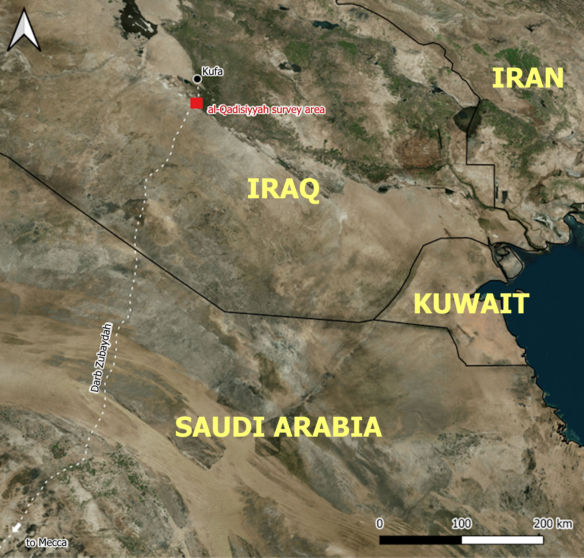
Figure 1: location of the al–Qadisiyyah remote sensing survey area at the northern end of the Darb Zubaydah, on the edge of the North Arabian desert. Background: Bing Aerial imagery © Microsoft 2025.
This will be achieved through:
• Drone and rapid ground survey of the main sites
• Recording the pottery and other finds (leaving all in situ)
• Generating drone orthomosaics and DEMs to analyse the sites and produce detailed plans
• Comparing this new data to published examples of Sasanian landscapes
• Investigating al–’Udhayb’s later function as a Darb Zubaydah way station
Located at the boundary between Arabia and Mesopotamia, al–Qadisiyyah has major cultural and historical relevance to the region. The Battle of al–Qadisiyyah was a decisive victory in the Early Islamic conquests (Yusuf 1945). Umar, the second caliph, sent large forces to capture territory in Syria and Mesopotamia. After several preceding battles, the Muslim army under Sa’ad won a major victory over a much larger Sasanian army (Lewental 2011). Although victory at al–Qadisiyyah did not immediately bring the end of Sasanian rule in Mesopotamia, it did substantially weaken its position (Tabari in Friedmann 1992). Thus, al–Qadisiyyah opened the door for the Muslim conversion of Persia and the rest of the Sasanian Empire and ultimately the Arab domination of the Middle East (Morony 1976). The battle has huge
cultural significance to the Arab and Muslim world (Lewental 2014) – it is taught in schools, features in Arabic film and television, and lends its name to professional football clubs in Kuwait, Saudi Arabia and Jordan. The modern Iraqi governorate of al–Qadisiyyah was renamed in honour of the battle, alongside for example, Babylon, Nineveh and Wasit (Baram 1991: 61).
Methodology
The sites of al–‘Udhayb and al–Qadisiyyah were identified by combining remote sensing and historical evidence. Especially compelling was the discovery of a six–mile double wall running between the sites, a large defensive trench and a likely Sasanian fortress, all described in historical accounts (Deadman et al. 2025). Keenly aware of the many threats facing Iraqi archaeology (Hopper et al. forthcoming), a rapid survey of these internationally significant sites was undertaken.
Initial orthomosaics were generated and examined prior to the ground survey. With little time available, the fieldwork largely consisted of photographing the main features. Finds were photographed in the field but not collected. More precise photogrammetry was carried out afterwards to generate more precise orthomosaics and accurate DEMs. These were utilised to produce site plans and illustrations.
Results
Drone survey was carried out at five sites across the study area. Each was also recorded on the ground, along with nine other significant localities in the landscape (Figure 2).
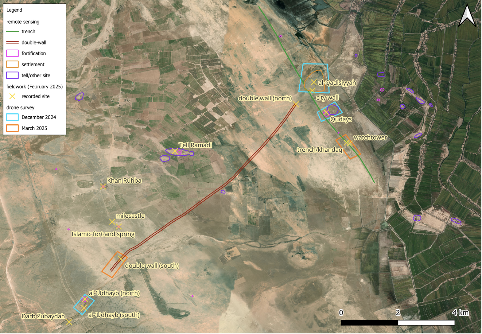
Figure 2: fieldwork carried out as part of the project, including sites recorded on the ground and areas covered by drone survey. Background Bing Aerial imagery © Microsoft 2025.
Al–Qadisiyyah, also known as Tell Mudheef al–Hassan (Directorate General of Antiquities 1976: map 110), is a 2–3m high, irregular tell. The low mound is ~27ha, but the settlement wall encloses a larger area of ~42ha (Figure 3).

Figure 3: KH9 Hexagon imagery (courtesy of the USGS), drone orthomosaic, drone DEM and combined VAT plot (cf. Kokalj and Somrak 2019) of the city of Qadisiyyah.
Al–Qadisiyyah lies immediately behind the central section of an 8km trench running parallel to the desert–floodplain boundary. Approximately 35m wide, with a subtle ditch profile, it has eroded upcasts on both sides. The eastern upcast is more substantial, likely once a fortified rampart, standing up to 2m high and 26m wide (Figure 4).

Figure 4: oblique drone photograph of the trench (looking north). Photo: Ali al–Gbur
Al–‘Udhayb lies ~11km WSW of the battlefield sites. On the north bank of Wadi Talah is the main fort, the foundations of around a dozen smaller rectilinear buildings, and two large water cisterns. More building foundations lie on the other side of the road to the west. On the southern bank is a large rectangular brick structure ~30x23m and ~2.5m high. There is also two circular birkat, water storage ponds, ~32m and ~12m in diameter. Two square wells lie ~70m south of the main structure. Dozens of smaller rectilinear buildings foundations survive to the west and east (Figure 5).

Figure 5: annotated KH9 and drone orthomosaic of al–‘Udhayb.
Pottery and other finds
Most of the sites yielded a similar assemblage of ceramics, dominated by turquoise glazed ware and an associated unglazed greenish buff ware. A coarse red–brown ware was less common. Green–blue glass and vitrified slag were also commonly observed. Qudays was unusual in producing no turquoise glaze. It was also the only site where Torpedo jar sherds were observed. While the pottery needs to be studied in more detail, a preliminary analysis suggests that the finds are consistent with an Early Islamic date, with perhaps small amounts of later material. As a Sasanian military site that does not seem to have been much occupied into the Early Islamic period , Qudays’ differing assemblage may be explained by chronological or functional factors.
Site condition
Tragically, many of these sites are in a very poor condition (Figure 6). Al–Qadisiyyah is in a relatively good state, with only some damage caused by irrigation channels and building on the site margins. Qudays was ploughed as part of a new pivot irrigation field in the autumn of 2024. A 5m–wide ditch has been dug through one of the best surviving sections of the defensive trench. Much of the double–wall has been flattened and incorporated into expanding arable farmland. The fort, rectangular building and wider landscape at al–‘Udhayb was severely quarried during the building of the modern road and bridge in the 1970s.

Figure 6: KH9, drone orthomosaic and VAT plot of Qudays (above) and al–‘Udhayb fort (below).
Discussion
This brief survey of these historic sites has done much to augment our understanding of this fascinating Sasanian and Early Islamic landscape. Clearly the area was heavily militarised during the Sasanian period – with forts at al–‘Udhayb, Qudays, and quite probably Tulul Ramadi, Qasr Ruhaym and Khan Ruhba. This seems to have been part of a much larger Sasanian frontier fortification system with a whole network of forts at the desert edge (Finster and Schmidt 2005; Lawrence and Wilkinson 2017). The trench/khandaq must certainly have played a major part in this system. It demonstrates a remarkable resemblance to the Gorgon Wall, the Sasanian northern frontier, which also consists of a substantial wall and ditch (Hopper 2017). What is less clear is whether the trench forms part of the Khandaq Shapur,
The double–wall between al–Qadisiyyah and al–’Udhayb is clearly of a very different character to the trench/khandaq. It could well be a canal redirecting seasonal flow from Wadi Talah, or possibly spring water with the many springs in the area only drying up relatively recently. It certainly represents a major investment with the two substantial earth bunds stretching for ~10km, but then ambitious water management systems are a signature of the Sasanian Empire (Adams 1965; Lawrence & Wilkinson 2017). Indeed, the feature looks very similar to canals associated with the Gorgan Wall (Wilkinson et al. 2013: 54) and the Mughan Steppe (Alizadeh 2021). It is also possible that the double–wall feature is in fact just a section of the Darb Zubaydah – an elaborate pathway rather than a canal, with the walls to protect the
route from being obscured by windblown desert sediments. The basic form does broadly resemble the stony desert route beyond al–‘Udhayb. More detailed investigation is needed to firmly establish the feature’s date and function, but parallels with the Gorgan Wall do look the most convincing for both the double–wall and trench (Figure 7).

Figure 7: scaled KH9 and Corona imagery (courtesy of the USGS) of Qudays, the double–wall feature, Gorgan Wall defences and canal, and a northerly, stony desert section of the Darb Zubaydah.
size and form to the less substantial structures at several DZ stations (Figure 9).
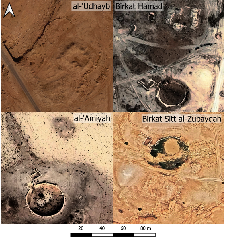 Figure 8: drone orthomosaic of al-‘Udhayb and Google Earth imagery (© 2025) of Darb Zubaydah parallels at Birkat Hamad, al-‘Amiyah and Birkat Sitt al-Zubaydah.

Figure 9: drone orthomosaic of al–‘Udhayb and Google Earth imagery (© 2025) of Darb Zubaydah parallels at Umm Qurun, Talhat and ‘Aqabah.
This project has succeeded in mapping and rapidly recording the Sasanian and Early Islamic sites of al–Qadisiyyah and al–‘Udhayb. By combining drone photogrammetry and ground survey it has augmented our understanding of the military, religious and agricultural landscape of this historically significant region.
research will facilitate the protection of these globally significant sites.
Acknowledgements
We wish to acknowledge the generous support of IASA which funded this work. Thanks also to the British Academy, which indirectly funded our travel expenses through the “landscapes of Tell Ramihiah” project, and to the Arcadia Foundation as the main funder of the EAMENA project. We also wish to thank our friends and colleagues at the University of al–Qadisiyyah, the University of Kufa and the State Board of Antiquities and Heritage that made this
research possible.
Bibliography
Adams, R.M., 1965. Land behind Baghdad: a history of settlement on the Diyala plains. University
of Chicago Press: Chicago.
Alizadeh, K., Rouhollah Mohammadi, M., Maziar, S. and Feizkhah, M. 2021. The Islamic Conquest or Flooding? Sasanian Settlements and Irrigation Systems Collapse in Mughan, Iranian Azerbaijan. Journal of Field Archaeology 46: 316–332.
Baram, A. 1991. Culture, history, and ideology in the formation of Baʻthist Iraq, 1968–89. St. Martin’s Press: New York.
Blunt, A. 1881. A pilgrimage to Nejd: the cradle of the Arab race. John Murray: London.
Deadman, W.M., Jotheri, J., Kopper, K., Almayali, R., al–Luhaibi, A.A. and Crane, C. 2025. Locating al–Qadisiyyah: mapping Iraq’s most famous Early Islamic conquest site. Antiquity 99 (403): e6, 1–8.
Directorate General of Antiquities. 1976. Atlas of the Archaeological Sites in Iraq. Ministry of Information: Baghdad.
Facey, W. 2022. Charles Huber: France’s Greatest Arabian Explorer. Arabian Publishing: Surbiton.
Finster, B. & Schmidt, J. 2005. The origin of ‘desert castles’: Qasr Bani Muqatil, near Karbala, Iraq. Antiquity 79: 339–349.
Friedmann, Y. 1992. The history of al–Tabari, volume XII, the Battle of al–Qadisiyyah and the conquest of Syria and Palestine. State University of New York Press: Albany.
de Goeje, M.J. 1889. Kitâb al–masâlik wa’l–mamâlik (Liber viarum et regnorum), auctore Abu ‘l– Kâsim Obaidallah ibn Abdallah ibn Khordâdhbeh; et excerpta e Kitâb al–kharâdj, auctore Kodâma ibn Djaʻfar. Leiden: Brill (in Arabic).
Hopper, K. 2017. Connectivity on a Sasanian frontier: Route Systems in the Gorgan Plain of North–East Iran. In Sauer, E. (ed.), Sasanian Persia: Between Rome and the Steppes of Eurasia. Edinburgh University Press: Edinburgh, 126–150.
Lawrence, D. and Wilkinson, T.J., 2017. The northern and western borderlands of the Sasanian
Empire: contextualising the Roman/Byzantine and Sasanian frontier. In Sauer, E. (ed.), Sasanian Persia: Between Rome and the Steppes of Eurasia. Edinburgh University Press: Edinburgh, 99–125.
Lewental, D.G. 2014. ‘Saddam’s Qadisiyyah’: Religion and History in the Service of State Ideology in Baʿthi Iraq. Middle Eastern Studies 50: 891–910.
Lewental, D.G. 2011. Qādisiyyah, then and now: a case study of history and memory, religion, and nationalism in Middle Eastern discourse. Brandeis University. Unpublished PhD thesis.
Kokalj, Ž. and Somrak, M. 2019. Why not a single image? Combining visualizations to facilitate fieldwork and on–screen mapping. Remote Sensing 11: 747.
Morley, C. 2017. The Arabian Frontier: A Keystone of the Sasanian Empire. In Sauer, E. (ed.), Sasanian Persia: Between Rome and the Steppes of Eurasia. Edinburgh University Press: Edinburgh, 268–283.
Morony, M. G. 1976. The Effects of the Muslim Conquest on the Persian Population of Iraq, Iran 14: 41–59.
Musil, A. 1928. Northern Negd: a topographical itinerary. American Geographical Society of New York: New York.
Petersen, A. 1994. The archaeology of the Syrian and Iraqi Hajj routes. World Archaeology 26: 47–56.
al–Rashid, S.A.A. 1977. A critical study of the pilgrim road between Kufa and Mecca (Darb Zubaydah) with the aid of fieldwork. University of Leeds. Unpublished PhD thesis.
UNESCO. 2025. The Hajj Pilgrimage Routes: The Darb Zubaydah (Saudi Arabia).
https://whc.unesco.org/en/tentativelists/6577/. Accessed 01/05/2025.
Wilkinson, T.J. 1980. Darb Zubayda — 1979: The Water Resources. Atlal 4: 51–67.
Wilkinson, T. J., Rekavandi, H. O., Hopper, K., Priestman, S., Roustaei, K., & Galiatsatos, N. 2013. The Landscapes of the Gorgān Wall. In Sauer, E.W., Rekavandi, H.O., Wilkinson, T.J. and Nokandeh, J. (eds), Persia’s Imperial Power in Late Antiquity: The Great Wall of Gorgan and the Frontier Landscapes of Sasanian Iran. Oxbow Books: Oxford, 24–132.


